What's New?...
Changes to Cold / Windchill products for this season. The National Weather Service has simplified its suite of cold weather products to improve messaging of these hazards and provide better decision making services. The National Weather Service has also improved the watch, warning, and advisory criteria for the Extreme Cold suite of products to be climatologically based and informed by CDC, local forecasters, and partners. These efforts are based on years of public and partner engagements as well as social science research informing the National Weather Service Hazard Simplification project.
Specifically, on October 1, 2024, the following changes were made:
Wind Chill Watches/Warnings were consolidated into Extreme Cold Watches/Warnings
Wind Chill Advisory was replaced with Cold Weather Advisory
These products will be issued as Non-Precipitation Weather Messages (NPWs) and not Winter Weather Messages (WSWs).
See attached pdf and handout for more info.
Our criteria for issuance has changed based on a nationwide climatology and impact analysis.
Previous NWS Windchill criteria for entire area was:
-
- Windchill Advisory: -15F
- Windchill Watch/Warning: -25F
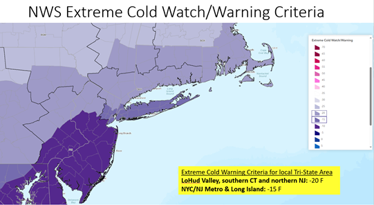
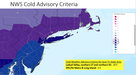
New Cold Weather / Extreme Cold criteria for the area:


Key Products and Services...
Through the winter season you can find our latest official NWS New York, NY snow, ice, and rainfall forecasts for the local Tri-State Region, including snowfall probability and percentile maps and tables for your area of interest, on our NWS New York NY Winter Weather Forecast Page.
To learn how to interpret probabilistic snowfall information, click here
NWS Experimental Winter Storm Outlook (WSO) - Displays the probability of realizing hazardous snow/ice accumulations using event-based and WFO-specific Watch/Warning criteria (6" for the local tri-State area) as a proxy threshold. This product is one of a few key factors considered in the issuance of official NWS Winter Storm Watches, and utilized in the coordination process between WPC & affected WFOs.
Read more